5. (a) How are geographic factors influencing the distribution of high annual rainfall in certain parts of India? (PYQ/2024)
Answer:
Introduction
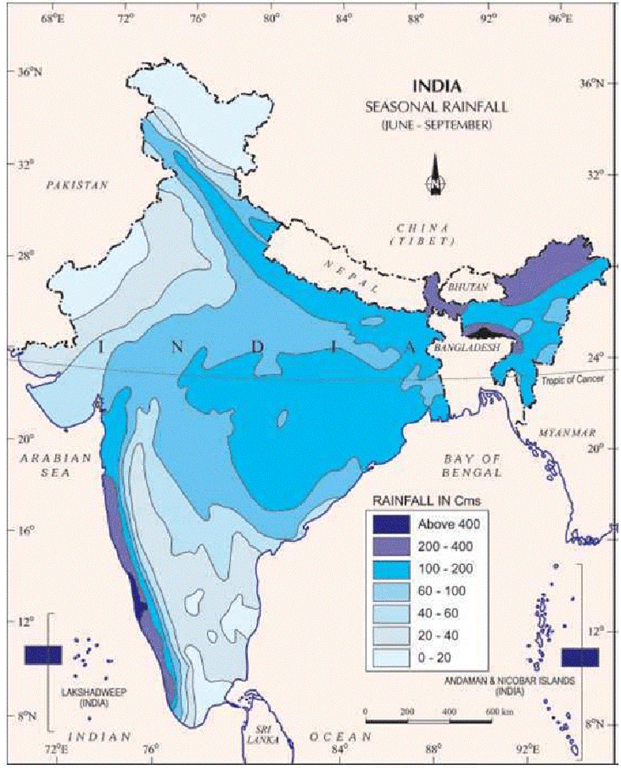
High annual rainfall in India is not uniformly distributed. Instead, it is strongly influenced by various geographic factors such as topography, altitude, proximity to water bodies, and regional climate patterns. For instance, the Western Ghats and the Northeast region receive exceptionally high rainfall due to orographic effects that force moist air masses upward, causing heavy precipitation. Understanding these spatial variations requires the application of locational analysis models, quantitative assessments, and interdisciplinary theories.

Models
Locational Analysis Models
- GIS-Based Spatial Analysis: Geographic Information Systems (GIS) are used to integrate satellite imagery, elevation data, and climatic parameters to map and quantify rainfall distribution. Quantitative analysis using indices like the Rainfall Variability Index enables researchers to pinpoint high rainfall zones. For instance, data from the India Meteorological Department (IMD) shows that certain regions of the Western Ghats record over 2000 mm of rainfall annually. Source: IMD Reports; Insights IAS (2024).
- Spatial Diffusion Models: These models explain the spread of rainfall patterns from high moisture zones (e.g., coastal areas) to inner regions. The Spatial Diffusion Model helps in understanding how proximity to the Arabian Sea or Bay of Bengal enhances rainfall along the adjacent coastal ranges and insular topographies.
Theories
Key Theoretical Frameworks
- Orographic Lifting Theory: Fundamental to understanding rainfall distribution is the Orographic Lifting Theory. This theory posits that mountain ranges (e.g., the Western Ghats and the Khasi Hills) force moist air upward, causing the air to cool and release its moisture as rainfall. Theorist: Although not attributed to a single theorist, this concept is a staple in physical geography and atmospheric sciences.
- Hadley Cell Theory: Hadley circulation explains large-scale patterns of atmospheric circulation, which alongside the monsoon system, drives the seasonal high rainfall in tropical regions of India. Theorist: George Hadley.
- Rain Shadow Effect: Conversely, the Rain Shadow Effect explains why regions on the leeward side of mountains (e.g., parts of the Deccan Plateau) receive significantly less rainfall.
Laws
Relevant Legal and Policy Frameworks
- National Environment Policy (NEP, 2006): This policy guides sustainable water resource management and addresses the impacts of climate variability, including changes in rainfall patterns.
- Environment (Protection) Act, 1986: Mandates the monitoring of environmental parameters, including rainfall distribution, to mitigate adverse ecological impacts. Source: Ministry of Environment, Forest and Climate Change, Government of India.
Perspectives
Integrated Perspectives on Rainfall Distribution
- Sustainable Development Perspective (Brundtland Commission): Focuses on balancing economic growth with environmental protection. It emphasizes the need for resilient water management practices that address both high rainfall and drought scenarios.
- Political Ecology Perspective (Rob Nixon): Highlights how geographical advantages (e.g., high rainfall zones) intersect with development challenges, influencing regional policies and resource allocations.
Case Studies
Case Study 1: Western Ghats Region
- Overview: The Western Ghats are renowned for high rainfall due to orographic forces. In areas like Chikmagalur and Agumbe, annual rainfall often exceeds 3000 mm.
- Data & Statistics: Agumbe in Karnataka is often cited as one of the wettest places in India, receiving over 8000 mm of rain annually. Source: Educemy Blog; INSIGHTS IAS.
Case Study 2: Meghalaya (Cherrapunji/Mawsynram Region)
- Overview: Located in Northeast India, this region receives record-breaking rainfall. Cherrapunji and Mawsynram are among the wettest places on Earth, with average annual rainfall ranging between 11,000 – 12,000 mm.
- Data & Statistics: These areas exhibit extreme rainfall variability, driven by the unique topography and the monsoon’s intensity. Source: INSIGHTS IAS; BBC Reports on Cherrapunji.
Conclusion
Geographic factors such as topography, altitude, and proximity to water bodies are key in influencing the distribution of high annual rainfall across India. By applying locational analysis models, the Orographic Lifting Theory, and supporting legal frameworks, researchers and policymakers can better understand and manage the challenges posed by such spatial variability. The case studies of the Western Ghats and Meghalaya vividly illustrate how these factors operate in practice, providing essential insights for sustainable development and water resource management.
Tag:distribution of high annual rainfall in parts of india, geograhic factors influencing rainfall, Geographic factors influencing annual rainfall in india, geographic factors influencing high annualrainfall, Geography Case Study, Geography Optional, geography optional case study, Geography Optional Pyq, geography optional pyq 2024, human geography, models theories laws and perspective in geography