

8. (a) How can morphology of Indian towns be described historically? Discuss the major features of the first planned city in India after independence. 20 Marks (PYQ/2024)
Answer:
Introduction
The morphology of Indian towns reflects a historical evolution from organic settlements to colonial urban structures and, eventually, modern planned cities. Early towns developed around forts, markets, and religious centers, fostering dense, irregular street patterns. Colonial interventions brought cantonments and civil lines, while post-independence urban planning introduced grid layouts and sector-based zoning.
Among India’s modern planned cities, Chandigarh stands as the first post-independence city. Designed by Le Corbusier with Pierre Jeanneret, it symbolizes India’s transition toward modernist urban planning principles, including functional zoning, hierarchy of roads, and environmental integration.
Urban Morphology Models
- E. Smailes Model (Urban Growth in India):
- Old Walled Towns – Dense, organic growth with irregular networks.
- Extra Mural Extensions – Expansions beyond historical cores.
- Cantonments & Civil Lines – Colonial influences introduced planned spaces for administration and military use.
- Modern Planned Areas – Post-independence grid-based cities with zoned land use.
- Burgess Concentric Zone Model (1925):
- A spatial growth model depicting cities evolving in concentric rings from a central business district (CBD).
- Though developed for American cities, Indian cities such as Delhi and Mumbai show similar patterns with old cores surrounded by expanding zones of commerce, industry, and residential areas.
- R.P. Mishra’s Urban Growth Model:
- Highlights regional disparity in city morphology.
- Suggests that planned cities like Chandigarh contrast sharply with organically growing towns such as Varanasi, emphasizing India’s dual urbanization process.
- Ashok Mitra’s Economic Urbanization Theory:
- Focuses on economic forces shaping urban growth.
- Analyzes how industrial expansion and job opportunities create growth poles, driving migration toward cities such as Mumbai, Kolkata, and Bangalore.
- GIS-Based Spatial Analysis:
- Geographic Information Systems (GIS) enable visualization of historical urban growth patterns.
- Research shows natural features (rivers, hills, walls) influencing early settlements, shaping urban expansion in cities such as Jaipur.
Urban and Modernist Planning Theories
- Lefebvre’s Production of Space:
- Ancient Indian towns reflect cultural and religious influences in their layout.
- Planned cities like Chandigarh represent modernist state ideologies, prioritizing efficiency and functional zoning.
- The Image of the City (Kevin Lynch):
- Emphasizes legibility in urban planning.
- Chandigarh’s ordered layout, sector-based planning, and hierarchical road network enhance clarity and efficiency.
- Modernist Urban Planning (Le Corbusier):
- Advocates functional segregation, hierarchy of streets, and integration of green spaces.
- Chandigarh exemplifies these principles, promoting planned urbanism over organic growth.
Planning Laws and Policies
- Town and Country Planning Act (1979) – Provides a legal framework for structured urban development.
- Sustainable Urban Development Policies – Indian policies increasingly emphasize eco-friendly cities, affecting designs like Chandigarh.
Perspectives on Urban Growth
- Political Economy Perspective (Immanuel Wallerstein):
- Examines state-led urbanization and how cities like Chandigarh reflect governance strategies.
- Planned cities serve as symbols of modern economic and political stability.
- Sustainable Development Perspective (Brundtland Commission):
- Advocates urban spaces balancing economic growth with ecological concerns.
- Chandigarh’s green belts embody this principle.
Case Studies
Varanasi – An Ancient Organic Town
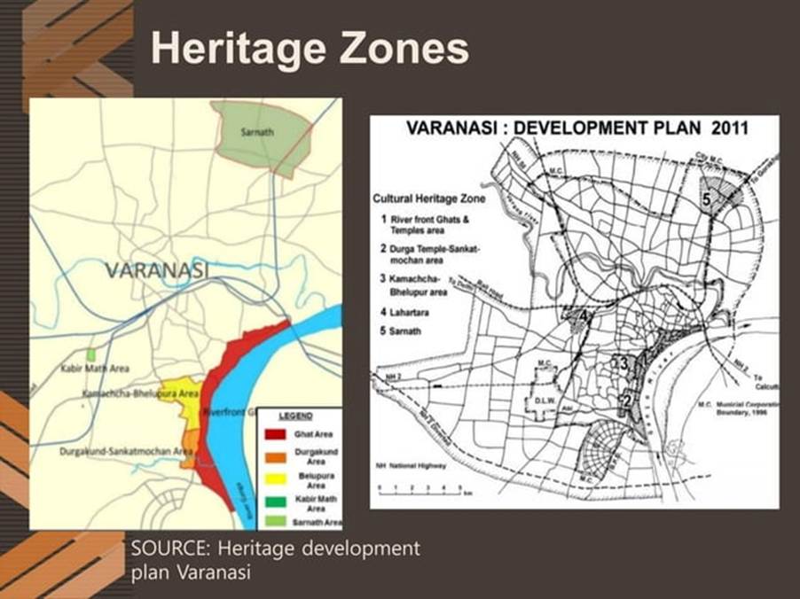
- Urban Form: Narrow lanes, organic clustering around temples and ghats.
- Demographic Data: Census 2011 recorded 1.2 million residents.
- Growth Pattern: Follows natural expansion rather than state-planned zoning.
Chandigarh – The First Planned City
- Urban Form: Grid-based, sector-oriented.
- Designed in the 1950s with functional zoning and green spaces.
- Population Density: ~4,000 persons/km² (Census 2011).
Conclusion
The morphology of Indian towns highlights a shift from organic settlements to modernist planning. The integration of theoretical models, laws, and planning perspectives helps frame this transition, shaping India’s urban landscape. Chandigarh stands as a benchmark for planned urban growth, contrasting sharply with organically grown cities such as Varanasi. This urban transformation reflects India’s evolving socio-economic and governance priorities.

