
(b) Describe latitudinal distribution of Köppen’s classification of world climate. 15 Marks (PYQ/2024)
Geography Optional – Climatology – Climate Classification
Answer:
Introduction
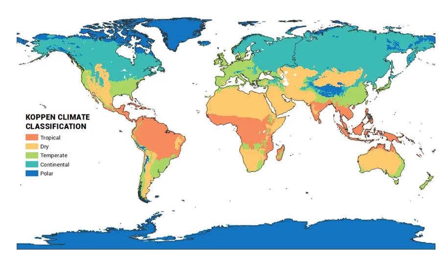
Wladimir Köppen (1846–1940), a German climatologist, developed the Köppen Climate Classification in 1884 (revised in 1918 and 1936), integrating empirical temperature and precipitation data with vegetation zones. It remains one of the most widely accepted climate classification systems. Köppen's system has a clear latitudinal structure, influenced by solar radiation, atmospheric circulation, ocean currents, and continentality.
Structure of Köppen’s Classification
Köppen classified the world’s climates into five major groups (A, B, C, D, E) based on mean monthly temperature and precipitation:
| Code | Climate Group | Characteristics |
| A | Tropical | High temp & rainfall, near Equator |
| B | Dry | Arid and semi-arid, evaporation > precipitation |
| C | Warm Temperate | Mild winters, distinct seasons |
| D | Cold Temperate | Cold winters, snow cover |
| E | Polar | Extremely cold, tundra and ice caps |
Latitudinal Distribution
1. Equatorial Zone (0°–10° N/S) – Tropical (A Climates)
- Af (Tropical rainforest): Amazon Basin, Congo Basin, Indonesia.
- High insolation and convectional rainfall due to ITCZ.
Model Reference: Global Heat Budget and Hadley Cell circulation explain convectional rainfall and energy surplus.
2. Subtropics (10°–30° N/S) – Arid and Semi-Arid (B Climates)
- BWh (Hot desert): Sahara, Thar, Sonoran.
- BSh (Steppe): Sahel, Deccan Plateau.
- Linked to descending limbs of Hadley Cells and subtropical high pressure zones.
Theoretical Link: Dynamic Climatology and Trade Wind Inversion contribute to aridity.
3. Mid-Latitudes (30°–45° N/S) – Warm Temperate (C Climates)
- Cfa (Humid subtropical): SE USA, China, NE Argentina.
- Csb (Mediterranean): California, Mediterranean Basin, SW Australia.
Perspective: Rossby Waves and Westerlies influence cyclonic precipitation.
4. Higher Latitudes (45°–65° N) – Cold Temperate (D Climates)
- Dfb (Humid continental): Canada, Siberia, Northern Europe.
- Marked by continentality, seasonal extremes, and snowfall.
Theory: Continentality Principle (Gorczynski) explains the severe temperature contrast.
5. Polar Regions (65°–90° N/S) – Polar (E Climates)
- ET (Tundra) and EF (Ice Cap): Greenland, Antarctica, Arctic.
- Minimal solar energy, permafrost, and extreme seasonality.
Case Study 1: Mediterranean Region (Csa Climate)
- Found between 30°–45° N/S, west coasts.
- Winter rainfall due to mid-latitude cyclones, dry summers due to subtropical highs.
- Supports Mediterranean agriculture: olives, grapes, citrus.
Model Connection: Linked to Monsoonal Drift and seasonal shifting of pressure belts.
Case Study 2: Sahel Region (BSh Climate)
- Transitional zone between tropical rainforest and desert.
- Undergoes climatic variability and desertification risks.
- Rainfall highly dependent on ITCZ movement.
Contemporary View: Climate change and ENSO variability are affecting the rainfall reliability in this region.
Conclusion
Köppen’s classification reflects a strong latitudinal pattern, shaped by solar radiation, global pressure belts, and ocean-atmosphere interaction. Despite criticism for not including air masses or seasonal wind shifts, it remains a functional and vegetation-linked climatic framework. Modern climatology often integrates Köppen with Trewartha’s modification, dynamic climatology, and GIS-based mapping, enhancing its relevance in the study of climate zones and biogeography.
Tag:(b) Describe latitudinal distribution of Köppen’s classification of world climate. 15 Marks (PYQ/2024), climate classification, climatic classification, climatology, Geography Case Study, Geography Optional, geography optional case study, Geography Optional Pyq, geography optional pyq 2024, koppens climatic classification, latitudinal distribution of Köppen’s classification of world climate, latitudinal distribution of koppens classification

