MapPrep
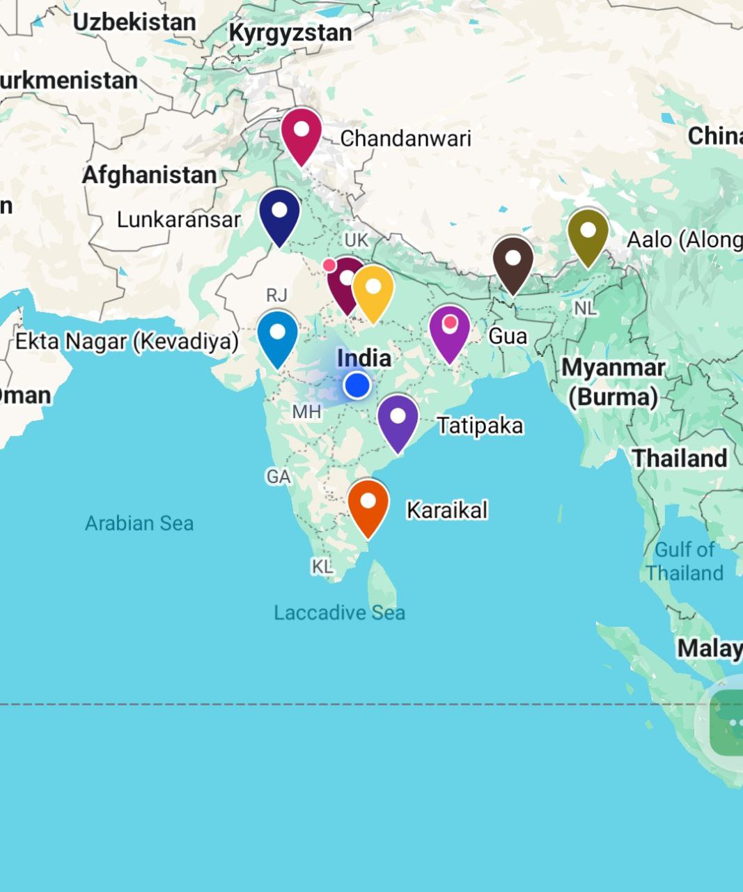
Click on the link Provided below to view on Google Map:
Indian Mapping – 2024 – Google My Maps
1. (a) On the outline map of India provided to you, mark the location of all of the following. Write in your QCA Booklet the significance of these locations, whether physical/commercial/economic/ecological/environmental/cultural, in not more than 30 words for each entry: 2×10=20
(i) Lunkaransar
📍 Absolute Perspective Located ~28.8°N in western Rajasthan’s Bagar tract, Lunkaransar lies in an arid climatic zone characterized by sandy alluvium, saline depressions, and xerophytic scrub vegetation. It falls within the tropical desert (BWh) zone of Köppen classification and is part of the Thar desert physiographic division.
🌐 Relative Perspective Functionally situated near the India-Pakistan border, Lunkaransar reflects a fragile agro-ecological balance under desertification pressure. It plays a role in dryland farming via canal-irrigated patches and salt lake-based economy. The region demonstrates planning relevance in desert settlement strategies, groundwater management, and climate resilience frameworks, especially within Rajasthan’s Drought-Prone Area Programme (DPAP).
(ii) Gua
📍 Absolute Perspective Located ~22.2°N on the southern fringe of the Chotanagpur plateau, Gua lies in the humid subtropical belt with Precambrian iron-rich lithology and rugged plateau terrain.
🌐 Relative Perspective Gua anchors India’s iron mining economy within the Singhbhum craton, supporting industrialization through mineral linkage to steel hubs and dense tribal settlements in Jharkhand’s mineral frontier.
(iii) Raidak River
📍 Absolute Perspective Flowing near ~26.3°N, Raidak traverses the lower Himalayas and eastern floodplains under monsoonal climate, forming braided river patterns and fluvial alluvium zones.
🌐 Relative Perspective It sustains floodplain agriculture and tea plantations in North Bengal, serving as a vital tributary to the Brahmaputra, with ecological significance for riparian biodiversity and rural livelihoods.
(iv) Ekta Nagar
📍 Absolute Perspective Situated ~21.8°N in semi-arid Gujarat near the Narmada River, it occupies a tropical savanna climate belt with basaltic geology of the Deccan traps.
🌐 Relative Perspective Developed around the Sardar Sarovar reservoir, Ekta Nagar represents centralized hydrological planning and national symbolism, integrating tourism, water resources, and infrastructure development.
(v) Chandanwari
📍 Absolute Perspective Located ~34°N in the Kashmir Himalayas, Chandanwari lies in alpine terrain with temperate glacio-fluvial climate and snow-fed streams from the Pir Panjal range.
🌐 Relative Perspective A pilgrimage transit zone for Amarnath Yatra, it demonstrates high-altitude human-environment interaction, seasonal settlement dynamics, and disaster vulnerability in eco-sensitive zones.
(vi) Babina
📍 Absolute Perspective At ~25.3°N in Bundelkhand’s upland terrain, Babina lies in a semi-arid zone with granite-rich geology and dry deciduous vegetation belt under high insolation.
🌐 Relative Perspective Adjacent to Jhansi cantonment, Babina reflects strategic military planning in drought-prone regions, where agro-economy and settlement resilience depend on watershed and tank-based irrigation models.
(vii) Tatipaka
📍 Absolute Perspective Located ~16.6°N on the coastal plains of Andhra Pradesh, Tatipaka sits in tropical wet climate under deltaic geomorphology of the Godavari basin.
🌐 Relative Perspective It forms a key node in the KG Basin petroleum zone, linking offshore energy extraction with onshore refining and contributing to regional economic corridors and coastal settlement spread.
(viii) Along Airport
📍 Absolute Perspective Near ~28.2°N in Arunachal Pradesh’s rugged terrain, Along lies in humid subtropical climate with high orographic rainfall, dense forest cover and steep slopes.
🌐 Relative Perspective The airport boosts border connectivity, strategic mobility, and integrated tribal development—central to frontier settlement planning and regional resilience frameworks.
(ix) Karaikal
📍 Absolute Perspective At ~10.9°N on the Coromandel Coast, Karaikal features tropical maritime climate, sandy deltaic soils, and tidal coastal processes influencing its landform.
🌐 Relative Perspective A port-linked satellite enclave of Puducherry, Karaikal fosters fishing economy, religious tourism, and coastal urbanization under dual administrative governance and SDG-linked coastal management.
(x) Panna
📍 Absolute Perspective Around ~24.7°N in the Vindhyan plateau, Panna lies in subtropical climate with extensive deciduous forests, quartzite terrain, and Ken River’s fluvial geomorphology.
🌐 Relative Perspective Noted for diamond mining and Panna Tiger Reserve, it balances conservation goals with mineral extraction, ecotourism planning, and landscape-based sustainable development initiatives.

