
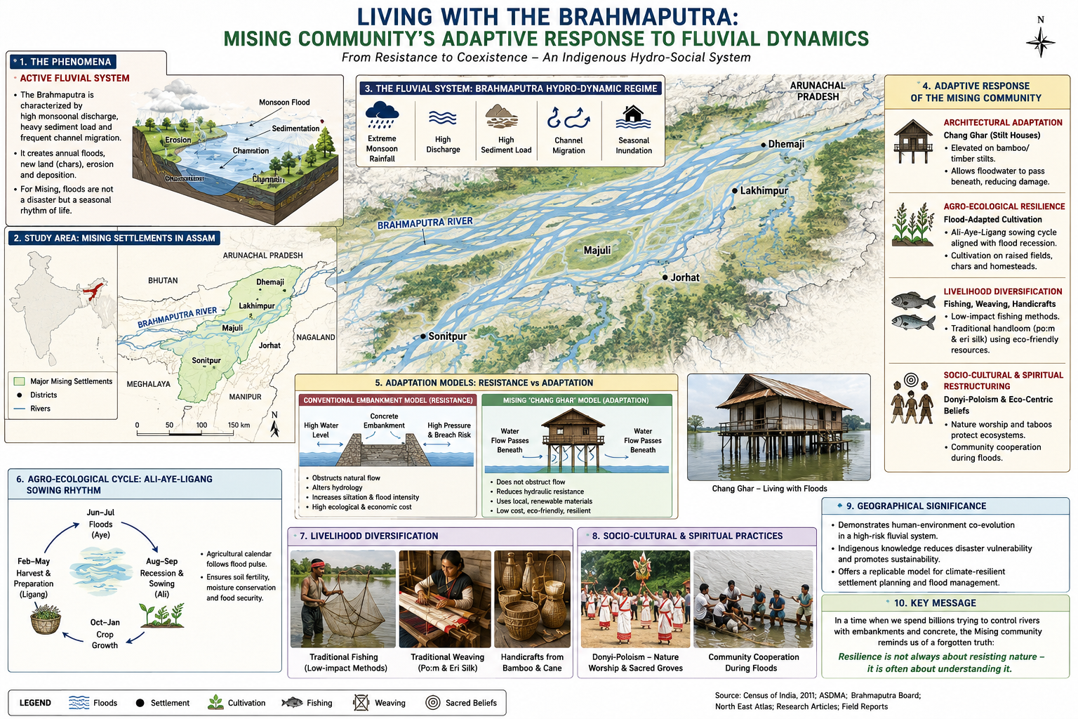
Living with the Fluvial Dynamics: A Cultural-Ecological Analysis of the Missing Community of Assam
             THE FLUVIAL CULTURAL-ECOLOGICAL SYSTEM
┌─────────────────────────────────────────────────────────────────────────┐
│              BRAHMAPUTRA HYDRO-DYNAMIC REGIME (RIVER)                   │
│   • Seasonal Monsoon Inundation, Sedimentation, & Channel Migration     │
└────────────────────────────────────┬────────────────────────────────────┘
                                     │
          ┌──────────────────────────┴──────────────────────────┐
          ▼                                                     ▼
 [ARCHITECTURAL ADAPTATION]                             [AGRO-ECOLOGICAL RESILIENCE]
 • 'Chang Ghar' (Elevated Stilted Stilts)               • Flood-Adapted Cultivation
 • Hydro-Dynamic Resistance Reduction                   • Seasonally Dynamic Land-Use
          │                                                     │
          └──────────────────────────┬──────────────────────────┘
                                     ▼
                [SOCIETAL & SPIRITUAL RESTRUCTURING]
   • Donyi-Poloism & Ali-Aye-Ligang Sowing Rhythms
   • Eco-Centric Taboos & Adaptive Knowledge Systems
1. Introduction: Hydro-Social Dynamics of the Brahmaputra Basin
The floodplains of the Brahmaputra river system represent one of the world’s most dynamic active fluvial environments. Governed by extreme monsoonal discharge, high sediment loads, and intense channel migration, the riverine landscape challenges conventional, engineering-heavy flood control paradigms.
In this flood-dominated environment, Assam’s Mising community—the state’s second-largest plains tribe—demonstrates an adaptive socio-ecological system. Settled across riverine districts such as Majuli, Dhemaji, Lakhimpur, Jorhat, and Sonitpur, the Mising have historically operationalized a paradigm of hydro-social coexistence rather than resistance. Analyzing their settlement morphology, livelihood strategies, and socio-cultural practices reveals how indigenous knowledge systems align with established geographical models of human-environment interactions, spatial adaptation, and cultural ecology.
2. Theoretical & Model-Based Geographical Dimensions
A. Cultural Ecology and Socio-Ecological Co-Evolution
- Theoretical Framework: Julian Steward’s Cultural Ecology and Carl Sauer’s Cultural Landscape Theory.
- Geographical Perspective: Steward’s framework posits that the “cultural core”—comprising subsistence techniques, technological tools, and social arrangements—adapts directly to environmental constraints.
                                [ENVIRONMENTAL CORE]
                       (Brahmaputra Hydro-Dynamics & Floods)
                                         │
                                         ▼
                                [CULTURAL ADAPTATION]
                       • Chang Ghar (Elevated Stilted Stilts)
                       • Ali-Aye-Ligang Sowing Cycle
                       • Low-Impact Fishing & Weaving
                                         │
                                         ▼
                               [CULTURAL LANDSCAPE]
                      (Harmonized Riverine Socio-Ecosystem)
For the Mising, the Brahmaputra is not a external hazard to be repelled, but an active co-creator of the landscape. Their cultural landscape features stilted architecture (Chang Ghar), low-carbon handloom traditions, and flood-adapted agricultural cycles. Rather than imposing an artificial structural boundary over the river, Mising settlement patterns transform environmental risk into an operational baseline, illustrating Sauer’s concept of the cultural landscape as a joint product of physical nature and human culture.
B. Architectural Adaptation & Hydro-Dynamic Resistance Reduction
- Theoretical Framework: Structural Adaptation in Natural Hazard Mitigation and Spatial Accessibility Models.
- Geographical Perspective: Conventional flood management relies on hard engineering (embankments, concrete dikes), which alters river hydrology, elevates bed levels via siltation, and creates catastrophic breach hazards.
CONVENTIONAL EMBANKMENT MODEL (RESISTANCE)
  Water Level ──► [ Concrete Barrier ] ◄── High Hydraulic Pressure & Breach Risk
  ─────────────────────────────────────────────────────────────────────────────

MISING 'CHANG GHAR' MODEL (ADAPTATION)
  Water Level ──► ── ── ── ── ── ── ── ──► Water Flow Passes Beneath
                 ======================= (Elevated Living Platform)
                 ||     ||     ||     || (Bamboo/Timber Stilts)
The Mising Chang Ghar utilizes structural adaptation. Raised on bamboo and timber stilts, these elevated dwellings allow seasonal floodwaters to pass beneath the living space without obstructing hydraulic flow. By utilizing locally available renewable materials (bamboo, thatch, timber), this low-density, flexible architectural model reduces hydraulic friction, minimizes infrastructure damage, and avoids the ecological footprint of rigid concrete structures.
C. Agro-Ecological Adaptation and Spatial-Temporal Mobility
- Theoretical Framework: Ester Boserup’s Theory of Agricultural Intensification and Spatial Diffusion of Adaptive Practices.
- Geographical Perspective: Boserup argued that agricultural systems adapt dynamically to environmental constraints through structural and technological adjustments.
The Mising agricultural strategy relies on spatial and temporal flexibility aligned with the river’s hydrological cycle. Instead of relying exclusively on monocultural paddy systems vulnerable to inundation, they cultivate flood-adapted indigenous crop varieties, adjust sowing schedules around the Ali-Aye-Ligang festival (held during the Assamese month of Fagun), and utilize seasonal crop rotations. Their reliance on micro-level environmental cues—such as observing ant behavior prior to heavy precipitation—represents a continuous spatial feedback loop that informs real-time disaster risk reduction.
D. Environmental Ethics, Taboos, and Common-Pool Resource Management
- Theoretical Framework: Elinor Ostrom’s Governing the Commons and Environmental Possibilism (Vidal de la Blache).
- Geographical Perspective: Vidal de la Blache emphasized that nature offers a range of possibilities, and human choices are guided by cultural values and social institutions.
                      DONYI-POLOISM & NATURAL ETHICS
                                     │
           ┌─────────────────────────┴─────────────────────────┐
           ▼                                                   ▼
[TABOOS & CONSERVATION RULES]                        [RESOURCE STEWARDSHIP]
* Prohibition of Tree Felling                        • Sustainable Low-Impact Fishing
* Protection of Sown Soil                            • Wetland & Ecosystem Preservation
The Mising faith—Donyi-Poloism (centered on the Sun and Moon) alongside nature deities like Kine Nane—operates as a functional institutional mechanism for resource conservation. Cultural taboos against felling trees or disturbing soil during specific ecological windows function as informal conservation laws. These spiritual guidelines mitigate the Tragedy of the Commons (Garrett Hardin) by establishing community-enforced boundaries that protect wetland biodiversity, riverine ecology, and topsoil integrity without reliance on state enforcement.
E. Fluvial Dynamics, Displacement, and Spatial Vulnerability
- Theoretical Framework: Piers Blaikie’s Pressure and Release (PAR) Model and Spatial Vulnerability Systems.
- Geographical Perspective: Blaikie’s PAR model evaluates disaster risk at the intersection of physical hazards and socio-spatial vulnerability ($Risk = Hazard \times Vulnerability$).
                      PRESSURE AND RELEASE (PAR) ANALYSIS
                      ====================================

      PHYSICAL HAZARD                              SOCIO-SPATIAL PRESSURES
┌───────────────────────────┐                ┌───────────────────────────┐
│ • Channel Migration       │                │ • Land Erosion & Losses   │
│ • Sedimentation           │       X        │ • Upstream Megadams       │
│ • Intensified Inundation  │                │ • Relocation Pressures    │
└─────────────┬─────────────┘                └─────────────┬─────────────┘
              │                                            │
              └─────────────────────┬──────────────────────┘
                                    ▼
                         [INCREASED DISASTER RISK]
                      (6-7 Historical Relocations/Family)
While Mising traditional knowledge provides internal resilience, external spatial pressures create growing vulnerability. Intensified bank erosion, channel migration, and upstream river regulation (e.g., large hydroelectric dams) alter historical flow regimes beyond the predictive capacity of inherited knowledge systems. As families are forced to relocate six or seven times due to land loss, their traditional spatial footprint shrinks, demonstrating how systemic external pressures can strain indigenous adaptive capacities.
3. Critical Analytical Synthesis
| Perspective | Theorists & Frameworks | Socio-Hydrological Mechanics & Empirical Evidence |
|---|---|---|
| Positive Perspective (Adaptive Harmony & Resilience) | Julian Steward (Cultural Ecology) & Elinor Ostrom (Commons Governance) | The Mising lifestyle demonstrates that indigenous knowledge systems offer viable, low-carbon models for climate adaptation. By integrating elevated architecture, flexible cropping calendars, and community resource stewardship, they maintain ecological balance, preserve riverine biodiversity, and reduce the financial burden of hard-engineering infrastructure. |
| Negative / Critical Perspective (Structural Constraints & Limits to Adaptation) | Piers Blaikie (PAR Vulnerability Model) & David Harvey (Spatial Fix) | Indigenous adaptation has operational limits when confronted with large-scale ecological disruption. Upstream dam construction, deforestation in upper catchments, and climate-induced hydrological shifts alter flow dynamics beyond traditional forecasting capabilities. Without formal spatial planning support, land rights security, and financial resources, traditional knowledge alone cannot fully offset severe land degradation and forced displacement. |
4. Policy Recommendations & Spatial Governance
To integrate the Mising community’s traditional ecological knowledge into regional climate resilience strategies, policy frameworks should consider the following actions:
- Incorporate Vernacular Architecture into Policy: Formally integrate the principles of stilted Chang Ghar construction into rural housing schemes (such as PMAY-G) across flood-prone riverine belts, reducing reliance on rigid, flood-disruptive concrete structures.
- Recognize Other Effective Area-based Conservation Measures (OECMs): Formally protect Mising community-managed wetlands, riverbanks, and agro-forestry zones under OECM frameworks to preserve local biodiversity and prevent habitat degradation.
- Combine Indigenous Knowledge with Early Warning Systems: Integrate traditional ecological indicators (such as biological cues and micro-climate observations) with modern hydro-meteorological forecasting to improve local disaster risk reduction programs.
- Implement Sustainable River Basin Planning: Shift from isolated structural interventions (like continuous embankments) toward integrated river basin management that maintains natural floodplain connectivity and protects indigenous land tenure against severe bank erosion.
5. Conclusion: The Big Picture
The Mising community’s relationship with the Brahmaputra offers an example of adaptive cultural ecology in a dynamic environment. Their lifestyle demonstrates that long-term resilience in flood-prone regions does not depend solely on technological control over natural forces. Instead, it relies on spatial flexibility, eco-centric institutional values, and an understanding of fluvial processes.
As climate change increases the frequency and severity of hydrological extremes, integrating traditional ecological knowledge with modern spatial planning provides a balanced path toward sustainable development and disaster risk reduction across fragile riverine landscapes.