Q. b Define ‘pseudo monsoon’ and explain its spatial distribution. (10)
Demystifying Pseudo Monsoons: Definition, Mechanisms, and Global Distribution
When most of us think of a monsoon, the dramatic downpours of South Asia or West Africa come to mind—driven by massive planetary wind shifts and the movement of the Intertropical Convergence Zone (ITCZ).
However, several parts of the world experience powerful seasonal shifts in wind and rainfall that mimic this phenomenon without meeting all the strict criteria of a classical monsoon. In climatology, these are known as Pseudo Monsoons (or monsoon-like circulations).
What is a Pseudo Monsoon?
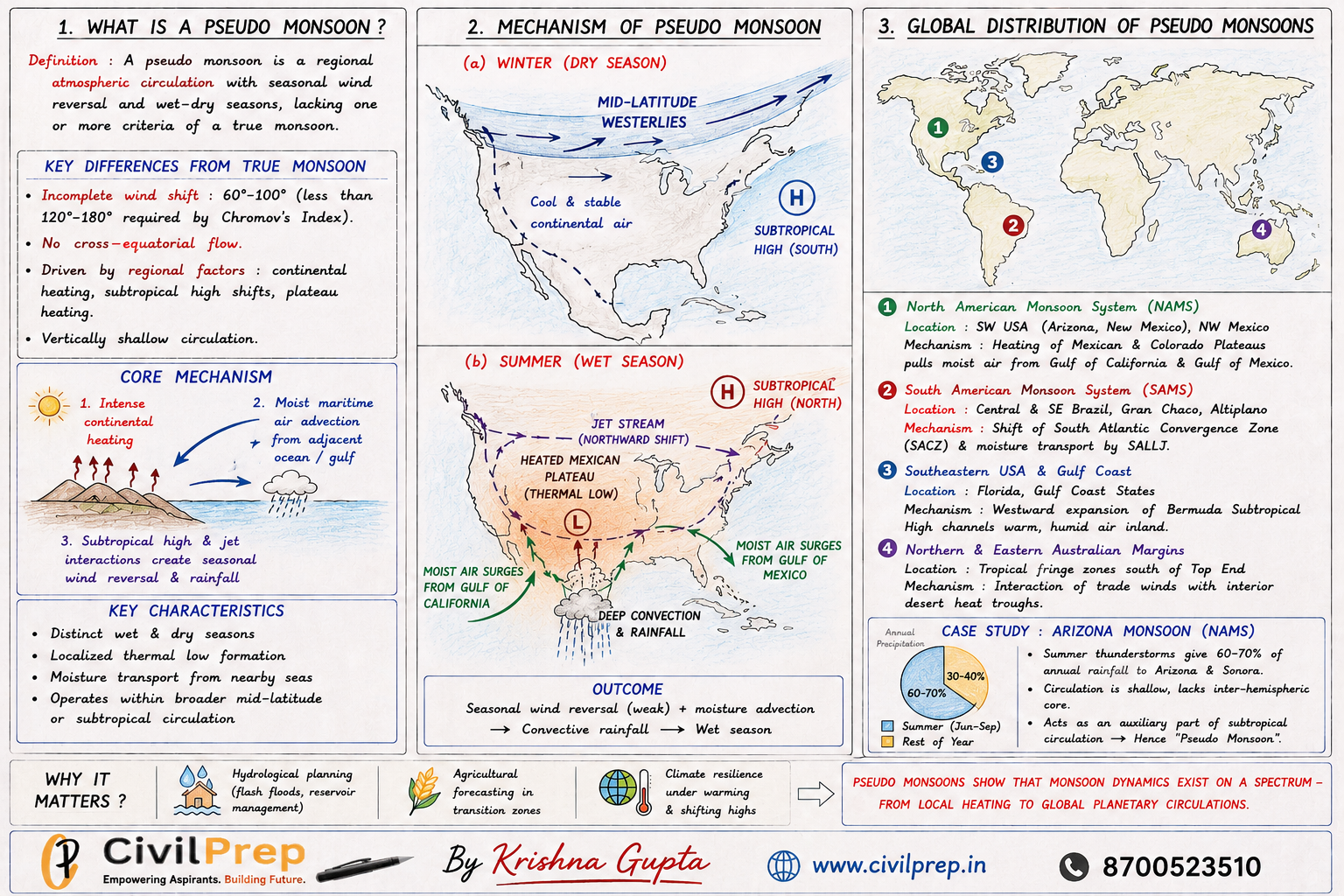
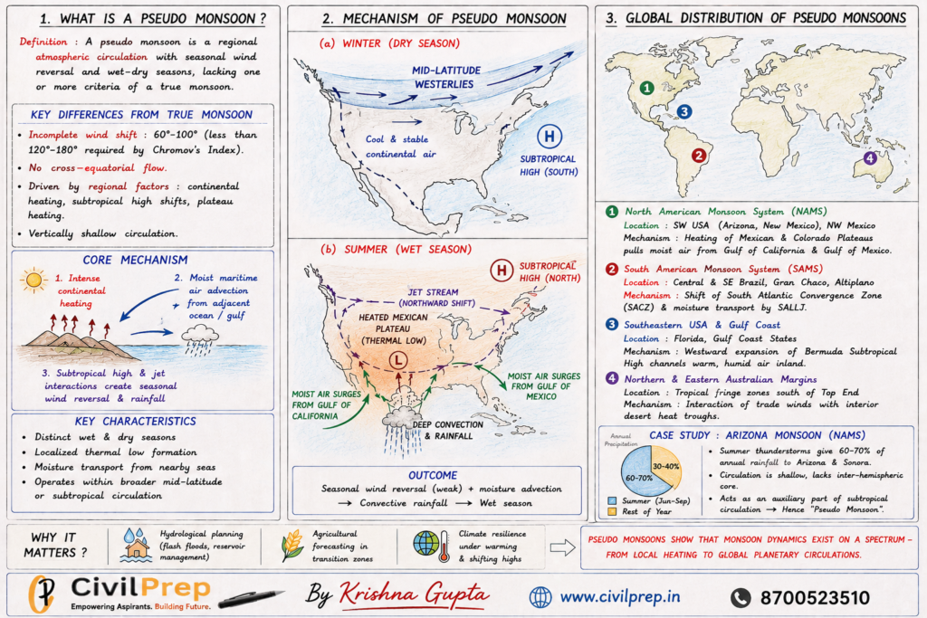
A pseudo monsoon is a regional atmospheric circulation pattern characterized by distinct seasonal wind reversals and pronounced wet–dry seasons.
While they produce monsoon-like weather, they lack one or more defining hallmarks of a “true” tropical monsoon:
- Incomplete Wind Shift: Classical monsoons require a directional wind reversal of at least 120 – 180 (as per S.P. Chromov’s Monsoonal Index). Pseudo monsoons often feature weaker shifts (60 – 100).
- Absence of Cross-Equatorial Flow: They do not originate from planetary-scale, inter-hemispheric air mass exchanges.
- Localized Drivers: Rather than being powered solely by massive planetary thermal belts, they are primarily triggered by regional thermal lows, subtropical anticyclone shifts, or elevated plateau heating.
Key Drivers & Mechanisms
- Intense Continental Heating: High summer insolation warms arid plateaus or continental interiors, creating shallow thermal lows.
- Moisture Advection: These localized low-pressure zones pull in moist maritime tropical (mT) air from adjacent oceans or gulfs.
- Subtropical Jet Interactions: Instead of replacing planetary wind belts entirely, pseudo monsoons often operate as regional perturbations superimposed on mid-latitude westerlies or subtropical trade winds.
Global Spatial Distribution
                   GLOBAL PSEUDO MONSOON BELTS
                                │
    ┌───────────────────────────┼───────────────────────────┐
    ▼                           ▼                           ▼
North America (NAMS)    South America (SAMS)        Subtropical Fringes
(SW USA & NW Mexico)    (Gran Chaco & Altiplano)    (SE USA & N Australia)
1. The North American Monsoon System (NAMS)
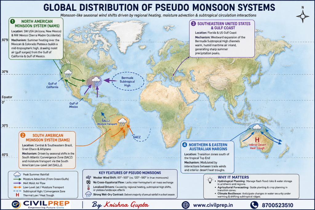
- Locations: Northwestern Mexico (Sierra Madre Occidental), Arizona, and New Mexico.
- Mechanism: Intense heating over the Mexican and Colorado Plateaus builds a mid-tropospheric high, drawing pulses of moist air (gulf surges) from the Gulf of California and Gulf of Mexico.
2. The South American Monsoon System (SAMS)
- Locations: Central/Southeastern Brazil, the Gran Chaco, and the Altiplano.
- Mechanism: Driven by seasonal shifts in the South Atlantic Convergence Zone (SACZ) and moisture transport via the South American Low-Level Jet (SALLJ).
3. Southeastern United States & Gulf Coast
- Locations: Florida and the US Gulf Coast.
- Mechanism: The seasonal westward expansion of the Bermuda Subtropical High channels warm, humid maritime air inland, generating sharp summer precipitation peaks.
4. Northern & Eastern Australian Margins
- Locations: Transition zones south of the tropical Top End.
- Mechanism: Modulated by interactions between trade winds and interior desert heat troughs.
Case Study: The “Arizona Monsoon” (NAMS)
The Southwestern United States and Northwestern Mexico offer the clearest real-world example of a pseudo monsoon in action:
- Winter Conditions: The region is governed by mid-latitude westerly flow and relatively dry continental air.
- Summer Shift: By late June, thermal heating over the elevated Mexican Plateau shifts the subtropical ridge northward, pulling gulf moisture into desert landscapes.
- Precipitation Impact: Convective thunderstorms during this period deliver 60% to 70% of the total annual precipitation for parts of Sonora and Arizona.
- Why It Is “Pseudo”: The circulation is vertically shallow, lacks an inter-hemispheric core, and remains an auxiliary component of subtropical circulation rather than a complete planetary wind reversal.
Why Understanding Pseudo Monsoons Matters
Pseudo monsoons show that monsoon dynamics operate across a continuous spectrum—from localized regional heating to global planetary circulations. Recognizing how these hybrid systems function is vital for:
- Hydrological Planning: Managing flash flood risks and reservoir storage in arid/semi-arid zones.
- Agricultural Forecasting: Predicting planting schedules in transition zones like the American Southwest and the South American Cerrado.
- Climate Resilience: Tracking how warming land surfaces and shifting subtropical ridges will alter seasonal water security.